Amérique Septentrionale...: D'Anville, 1746
- Title: Amérique Septentrionale Publiée sous les Auspices de Monseigneur le Duc d'Orleans, Prémier Prince du Sang
- Author: Jean-Baptiste Bourguignon d'Anville
- Date: 1746
- Condition: Excellent - minimal foxing in a few areas, minor marginal scuffing
- Inches: 38 1/4 x 36 3/4 [Paper]
- Centimeters: 97.16 x 93.35 [Paper]
- Product ID: 233102
This expertly detailed map of North America broadly encompasses the known parts of North America, Central America, and the West Indies, with its greatest detail concentrated east of the Mississippi, in Central America, along the Mexican coast as far as Baja, and inland along the Rio Grande (Rio del Norte) to the region of modern-day New Mexico, while, characteristically, D’Anville leaves the Transmississippi, Great Plains, Texas, and the Arctic largely blank, emphasizing the generally unexplored condition of those areas.
In drawing the map, D’Anville made extensive use of Native American cartographic knowledge reported by French missionaries, military officers, fur traders, and explorers in the Upper Mississippi and Great Lakes, with numerous instances—such as the river connection between the Lake of the Woods and Lake Winnipeg (not depicted but referenced textually as “Assenipoel Great Lake”)—in which his cartography explicitly credits indigenous groups, in this case the Assenipoel and the Oshagac, and he likewise notes American Indian groups and villages throughout the Lower Mississippi Basin.
The present map is the first edition, issued in 1746. It was drafted by J. B. B. D’Anville and engraved in Paris by Guillaume Delahaye, with the cartouche designed by Sr. Gravelot and engraved by Sr. Major. The map was published both as a separate issue and within various D’Anville and composite atlases, and while well represented in institutional collections, the first edition is uncommon on the market.
Background on Creator
Jean-Baptiste Bourguignon d’Anville (1697–1782) was a French geographer and cartographer who transformed eighteenth‑century mapmaking through his insistence on accuracy and critical use of sources. Born in Paris, he showed precocious talent, publishing his first serious map—of ancient Greece—while still in his teens and quickly gaining recognition for his meticulous research. Over his career he produced more than two hundred maps, including influential works on China, Italy, Africa, and Asia, and was known for omitting or blanking out regions where reliable information was lacking, a sharp break from the speculative practices of many predecessors. His achievements earned him appointments as geographer to the king of France and membership in leading learned societies, and his atlases and map collections became foundational references for both contemporaries and later geographers.
Original: $1,795.00
-65%$1,795.00
$628.25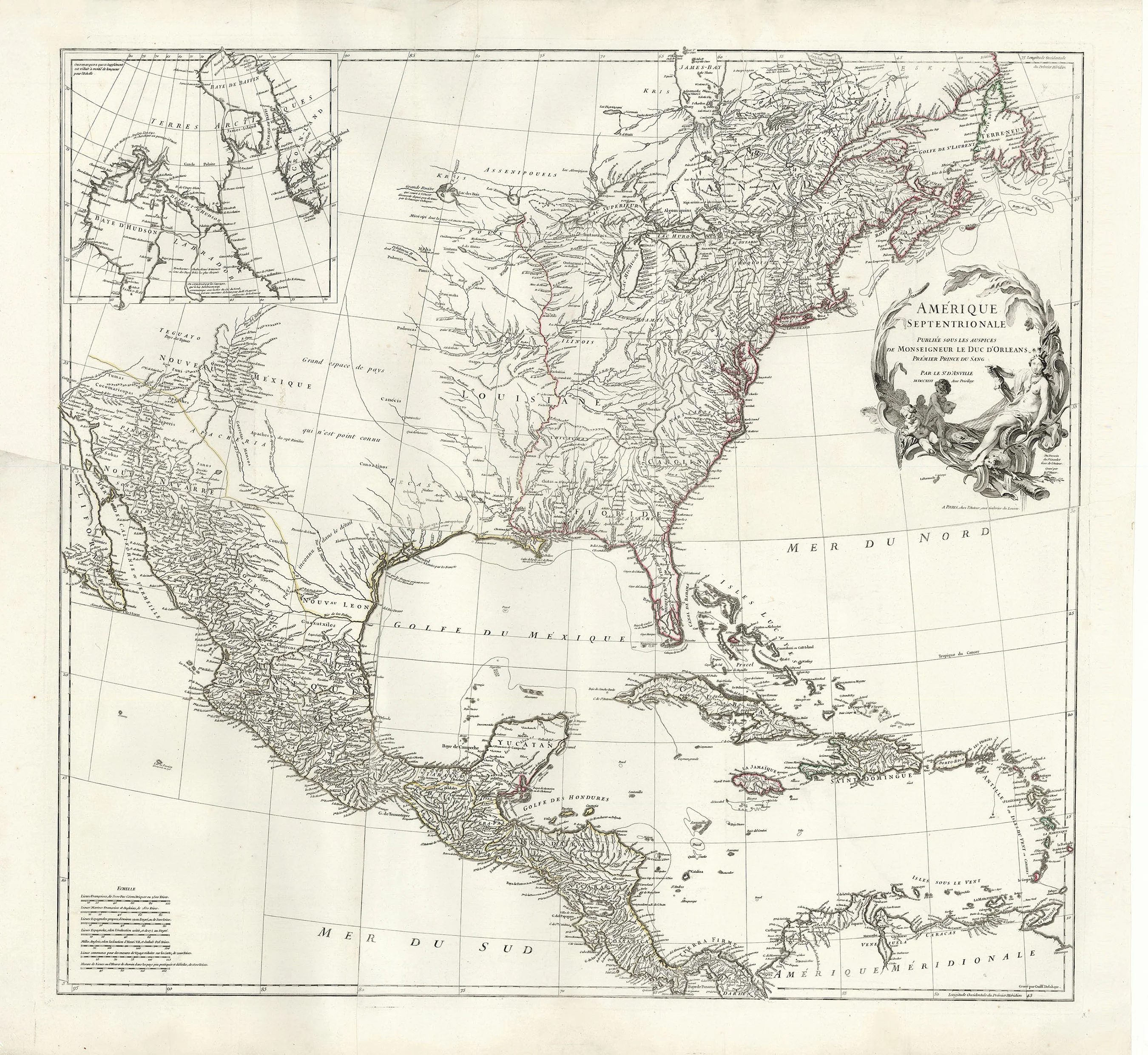
Description
- Title: Amérique Septentrionale Publiée sous les Auspices de Monseigneur le Duc d'Orleans, Prémier Prince du Sang
- Author: Jean-Baptiste Bourguignon d'Anville
- Date: 1746
- Condition: Excellent - minimal foxing in a few areas, minor marginal scuffing
- Inches: 38 1/4 x 36 3/4 [Paper]
- Centimeters: 97.16 x 93.35 [Paper]
- Product ID: 233102
This expertly detailed map of North America broadly encompasses the known parts of North America, Central America, and the West Indies, with its greatest detail concentrated east of the Mississippi, in Central America, along the Mexican coast as far as Baja, and inland along the Rio Grande (Rio del Norte) to the region of modern-day New Mexico, while, characteristically, D’Anville leaves the Transmississippi, Great Plains, Texas, and the Arctic largely blank, emphasizing the generally unexplored condition of those areas.
In drawing the map, D’Anville made extensive use of Native American cartographic knowledge reported by French missionaries, military officers, fur traders, and explorers in the Upper Mississippi and Great Lakes, with numerous instances—such as the river connection between the Lake of the Woods and Lake Winnipeg (not depicted but referenced textually as “Assenipoel Great Lake”)—in which his cartography explicitly credits indigenous groups, in this case the Assenipoel and the Oshagac, and he likewise notes American Indian groups and villages throughout the Lower Mississippi Basin.
The present map is the first edition, issued in 1746. It was drafted by J. B. B. D’Anville and engraved in Paris by Guillaume Delahaye, with the cartouche designed by Sr. Gravelot and engraved by Sr. Major. The map was published both as a separate issue and within various D’Anville and composite atlases, and while well represented in institutional collections, the first edition is uncommon on the market.
Background on Creator
Jean-Baptiste Bourguignon d’Anville (1697–1782) was a French geographer and cartographer who transformed eighteenth‑century mapmaking through his insistence on accuracy and critical use of sources. Born in Paris, he showed precocious talent, publishing his first serious map—of ancient Greece—while still in his teens and quickly gaining recognition for his meticulous research. Over his career he produced more than two hundred maps, including influential works on China, Italy, Africa, and Asia, and was known for omitting or blanking out regions where reliable information was lacking, a sharp break from the speculative practices of many predecessors. His achievements earned him appointments as geographer to the king of France and membership in leading learned societies, and his atlases and map collections became foundational references for both contemporaries and later geographers.